
Cycle America: Glacier/Waterton Lakes Parks 2000
Background
We decided to join Cycle America in the summer of 2000 on our way to Death Valley that March. We first considered the Grand Canyon/Zion/Bryce tour, but decided the Glacier/Waterton Lakes Park tour in August would provide more variety after Death Valley in the spring. We selected the camping option, rather than the motel option, and enjoyed meeting many other campers. The tour was organized by Cycle America and Pedal the Peaks, a company based in Cannon Falls, Minnesota.
Itinerary
| Day | Start | Stop | Mileage | Elevation Gain |
|---|---|---|---|---|
| July 24 | Bigfork, MT | West Glacier, MT | 41+ | 1890+ |
| July 25 | West Glacier, MT | St. Mary, MT | 52 | 3500 |
| July 26 | St. Mary, MT | Waterton Lakes, AB | 47 | |
| July 27 | Layover at Waterton Lakes National Park | |||
| July 28 | Waterton Lakes, AB | Coleman, AB | 68 | 3200 |
| July 29 | Coleman, AB | Eureka, MT | 91 | |
| July 30 | Eureka, MT | Bigfork, MT | 92 | 2800 |
Totals |
391+ | |||
Diary
23 July 2000 (Saturday)
Linda and I complete our drive to Bigfork, Montana on the shore of Flathead Lake after spending the night at perhaps the last available motel room in Coeur d'Alene, Idaho. We pick up our registration materials and set up our tent at the Bigfork High School, bicycle to the north shore of the lake, and then return for a walk downtown.
We catch the scheduled dinner just before the first evening's briefing and realize we needed to reset our watches for Mountain Time. We meet Cecil and Rosanne from Pennsylvania who have just completed the previous week's Yellowstone/Teton tour and are riding BikeE recumbents. This tour has people from diverse parts of the country and elsewhere and we are eager to see how the ride is organized. The young staff seems friendly and casual.
24 July (Sunday)
We leave Bigfork and ride north on Highway 35 through farmland, then continue north on Columbia Falls Stage Road. Here is our first "water stop", a cooler along the road with a can of Gatoraide mix perched on top. We continue north along pleasant, low traffic back roads until we join Highway 2 east. The traffic is much heavier here and there are spots with little or no shoulder.
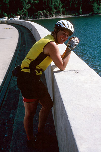
Linda on the Hungry Horse Dam
Linda and I enjoy the lunch stop at the Ranger Station in the town of Hungry Horse, then take the optional climb along a twisty mountain road to the Hungry Horse Dam. We cross the dam, then follow the western shoreline of Hungry Horse Reservoir a few miles before returning to Hungry Horse.
We continue east on the busy, rolling highway to Glacier Campground, a private campground just west of West Glacier. It was a fun day and a good shakedown for the trip. We learn at that evening's briefing that tomorrow we need an early start so we can make the climb to Logan Pass by 11AM, the official cutoff time for bicyclists ascending the Going to the Sun Road in Glacier National Park.
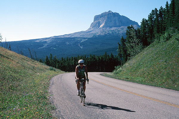
25 July (Monday)
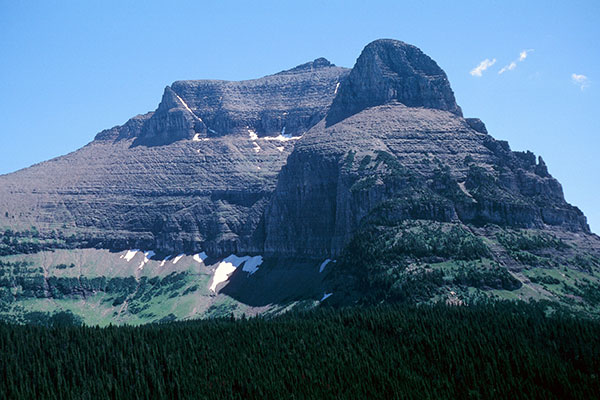
Going to the Sun Road
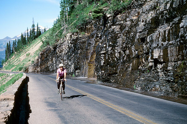
Weeping Wall along Going to the Sun Road
Mount Cannon from Going to the Sun Road
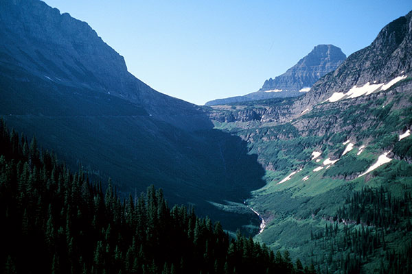
Today is a big day with a cool, early start. We ride through West Glacier and enter Glacier National Park before the sun strikes the road. We get our first glimpse of the impressive peaks as we ride along Lake McDonald. The road turns to the north, then switches back and the climb really begins. The road is narrow with little or no shoulder between it and a low, stone fence. On the other side of the fence is a steep drop. The climb is unrelenting, but not too steep and there is little traffic at first. We enjoy the climb, the refreshing "Weeping Wall", and the tremendous views. The traffic gradually increases and at times backs up behind Linda and I where the shoulder disappears along the low stone fence. We see Logan Pass gradually approach ahead of us. We cross some construction, then finish the climb to Logan Pass. Linda lingers behind to photograph mountain goats, but we both arrive at Logan Pass and lunch by the 11AM "deadline".
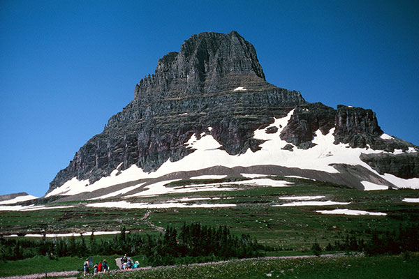
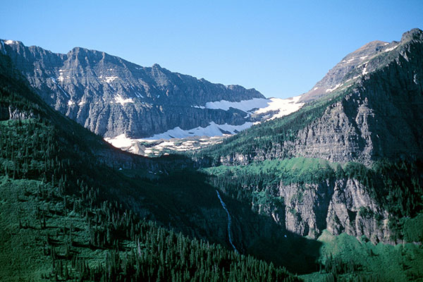
Clements Mountain from Logan Pass
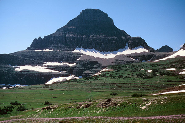
Reynolds Mountain from Logan Pass
Going to the Sun Mountain
Here we enjoy close views of several impressive mountains near the Visitors' Center before continuing east. I stop for several photographs on the fast descent and don't catch up with Linda for several miles. We leave the park, pass through Saint Mary, and find our campsite at the Johnson Campground at the top of a hill away from the RVs. It was a very scenic and memorable day of bicycling.
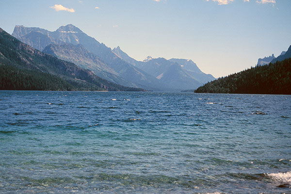
26 July (Tuesday)
Lower St Marys Lake
We leave the campground, turn north on Highway 89, and follow the eastern shore of Lower Saint Mary Lake. At the town of Babb some cyclists take an optional 25 mile out and back ride to Many Glacier in Glacier NP. We decide to continue north, instead.
Linda and Chief Mountain
Chief Mountain appears in the distance on our left. We turn northwest on Highway 17 (Chief Mountain International Highway) and we eventually pass close to Chief Mountain's north side as we climb for several miles.
After a short gravel section we reenter Glacier NP and descend to the Canadian border to enter Alberta and Canada's Waterton Lakes National Park. We continue the descent to the Belly River, then make one last climb to our lunch stop overviewing the Waterton Lakes area to the west.
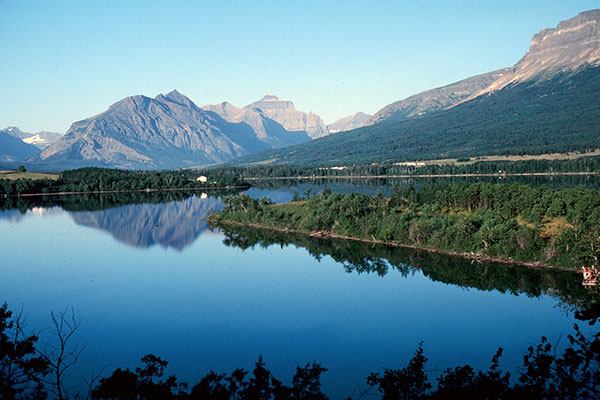
After lunch we enjoy a fast descent on straight and smooth asphalt, then turn towards the lakes and follow Upper and Middle Waterton Lakes to the town of Waterton Park beside Waterton Lake. The Prince of Wales Hotel rises on the knoll between Waterton and Middle Waterton Lakes with an excellent view of Waterton Lake and the impressive peaks surrounding the town and lake.
We pass through town, noting the mountain sheep wandering across streets, and find our camp for the next two nights at the far end of Waterton Lakes Campground. After setting up our tent we return to town to explore several shops before returning to camp for an excellent dinner provided by a Canadian catering company. We will enjoy several excellent meals prepared by this company during our stay in Canada.
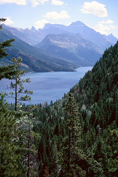
27 July (Wednesday)
Upper Waterton Lake
Today is a layover day at Waterton Lakes. Mount Crandell looks like a compelling rock scramble, but will have to wait for another visit. Instead, Linda and I hike the trail to Bears Hump on the southern shoulder of Mount Crandell and get good views of the town, lakes, and surrounding peaks.
From Bertha Falls Trail
We stop for a visit at the Prince of Wales Hotel, then pass back through town and camp to take the Bertha Falls Trail to the west. It is a pleasant stay at Waterton Lakes and a relaxing break from the daily bicycling routine.
28 July (Thursday)
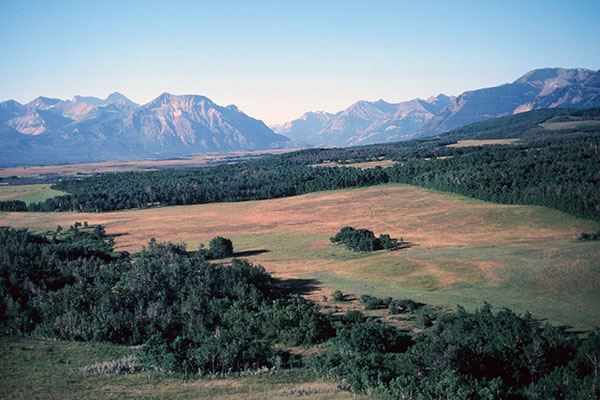
West of Pincher Creek, Alberta
Today is a longer day with lots of hills on good road. I feel strong after the layover day and maintain good speed on miles of rolling hills north on Highway 6 to the town of Pincher Creek. Here we turn west on Highway 507 towards the peaks and encounter a strong headwind. The headwind slows us down and we set a slower pace as we climb towards Crowsnest Pass.
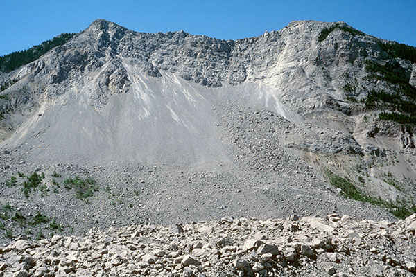
Jack Slide
We turn west on Highway 3 then stop at Jack Slide to read about and try to capture on film the massive rock slide of 1903 off Turtle Mountain which destroyed the town of Frank.
We pass the Frank Slide Interpretive Centre and Blairmore and continue to Coleman, where we spend the night at the Coleman High School. It is hot when we first arrive at Coleman, and we note how cool the gym is for those setting up their sleeping quarters there, but we decide to set up our tent outside, as usual, and are awarded in the evening and over night when it cools off nicely.
29 July (Friday)
Today is an even longer day with some significant climbs. We leave Coleman on Highway 3 and climb over Crowsnest Pass. We cross into British Columbia and descend into forests. We pass the "World's Largest Truck" in Sparwood, then cycle on to Fernie for lunch.
I'm feeling strong again, and after lunch I join a pace line and am able to maintain excellent speed for several miles. Then we enter a tunnel. My vision is obscured by other riders and the darkness in the tunnel and I hit a rock which blows my front tire. I'm able to exit the pace line and the tunnel and get off the road to fix the flat without further mishap. I decide not to join pace lines for the rest of the trip.
I wait for Linda before continuing and learn she has also had a flat a few miles back, and had to borrow another bicyclist's pump to adequately pump up her tire -- the tiny pump she is carrying is not adequate.
We continue on and stop for some excellent smoothies. We pass through Elko and turn south on Highway 93. It is getting hot and we encounter a big dip and climb of 2 miles and 8% grade.
We stop at a water stop a few miles beyond and learn that one of the bicyclists is having trouble with his tire repeatedly going flat. We later learn that he was impatient in the heat and was not taking the time to patch the tire, just repeatedly stopping and pumping the tire up as it lost pressure, then got so frustrated that he tossed the bike aside and waited for the SAG vehicle to take him in to camp.
We eventually arrive at the US border. It is 94 degrees and we take a Coke break at the Duty-Free shop before finishing the last 8 miles to Eureka. Camp is at the Eureka Elementary School.
We set up camp and get cleaned up, relax while watching a family fire rockets from the adjoining field and loose them among nearby homes (I join their search but we fail to find them), then walk downtown for dinner. Linda and Rosanne enjoy the desserts -- a well-deserved privilege at the end of a big day of bicycling.
30 July (Saturday)
Today is another long day, but not as much climbing as yesterday. We leave Eureka by way of several forest back roads for 8 miles before rejoining Highway 93 south. A big pace line passes, but I resist the temptation to join them. At 40 miles we leave the highway for another 9 miles of back roads before rejoining the highway once more and stopping for lunch along the Stillwater River.
After lunch we pass through Whitefish. The official route would have us take a complex and winding route on back roads, but Linda is eager to return to Bigfork in the most direct route possible so we stay on Highway 93 heading south. The the shoulder is wide, but the traffic is very heavy and I pick up a tiny wire and get a flat.
We continue south through Kalispell, staying on Highway 93 and look for but miss rejoining the official route. Continuing further south on Highway 93 we eventually find and turn onto Highway 82 and head east for Bigfork. The shoulder gets narrow and the traffic remains heavy so this calls for very attentive riding.
We eventually reach our finish at the Bigfork High School. We learn that a pace line crashed just outside of town and there are a few injuries. I'm glad I avoided them today. We clean up, load up our gear, say our goodbyes, and start for home. This was a fun adventure and we look forward to joining Cycle America's Grand Canyon/Zion/Bryce tour next year.
